May
The Eye in the Sky: A Comprehensive Guide to Agricultural Drones
For decades, “crop scouting” meant a farmer putting on boots and walking through rows of corn or wheat, looking for signs of stress, pests, or thirst. It was labor-intensive, subjective, and—most importantly—limited by the human perspective. If a problem started in the center of a 500-acre field, the farmer might not notice it until it was too late to save the crop.
Enter the Agricultural Drone, or Unmanned Aerial Vehicle (UAV). If traditional farming is like playing a strategy game with “Fog of War” enabled, drones are the ultimate map hack. They provide a high-resolution, “spectator mode” view of the farm, turning thousands of acres into actionable data points. As we move through 2026, drones are no longer just expensive toys for tech enthusiasts; they are the “frontend” of the modern precision agriculture stack.

1. What Are Agricultural Drones? (The Hardware & Software Synergy)
At its simplest, an agricultural drone is a flight platform equipped with specialized sensors. However, the true value lies in the synergy between the hardware (the bird) and the software (the brain).
The Hardware Layers – The Eye in the Sky
Modern drones come in two primary architectures:
Multi-rotor Drones: These look like the consumer drones you see at the park. They can hover, take off vertically (VTOL), and are incredibly maneuverable. They are perfect for detailed spot-checking and precision spraying.
Fixed-wing Drones: These look like small airplanes. They cannot hover, but they are much more efficient. A fixed-wing drone can cover ten times the area of a multi-rotor on a single battery charge, making them the “bulk processors” of the drone world.
The Sensor Array
The “eyes” of the drone are often more expensive than the drone itself. They don’t just take pretty pictures; they capture data across the electromagnetic spectrum.
RGB Cameras: Standard high-resolution visual imagery.
Multispectral Sensors: Capture specific wavelengths (like Near-Infrared) that indicate plant health.
Thermal Sensors: Detect heat signatures, which are vital for identifying irrigation leaks or “hot spots” of pest activity.
LiDAR: Uses laser pulses to create 3D maps of the terrain, helping with drainage planning and canopy volume measurements.
2. Key Uses: From Imagery to Action
Agricultural drones aren’t just for looking at things; they are for diagnosing and treating fields.
I. High-Resolution Crop Monitoring
This is the most common use case. By flying a pre-programmed “grid” pattern, a drone creates an Orthomosaic Map—a massive, high-detail image stitched together from hundreds of smaller photos.
Farmers use this to calculate the NDVI (Normalized Difference Vegetation Index). This mathematical formula compares the reflection of red light (which plants absorb for photosynthesis) and near-infrared light (which healthy leaves reflect).
Result closer to +1.0: High photosynthetic activity (Healthy).
Result closer to 0: Low activity or bare soil (Stressed/Dead).
II. Pest and Disease “Anomaly Detection”
In software development, we look for bugs in the code; in farming, we look for them in the leaves. Drones can identify subtle changes in leaf color or texture that indicate a localized infestation. By catching a pest outbreak when it is only 10 meters wide, a farmer can treat just that small patch, rather than spraying the entire 100-acre field.
III. Soil and Field Analysis
Before the seeds even hit the dirt, drones provide the “system requirements” check. Thermal and LiDAR sensors can create precise topographic maps to predict where water will pool and where the soil will dry out fastest. This allows for “Variable Rate Seeding”—planting more seeds in fertile areas and fewer in poor soil to maximize ROI.

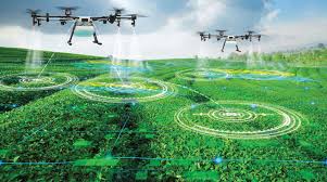
IV. Precision Spraying and Seeding
Some heavy-duty drones are “agricultural tankers.” These large UAVs can carry 20–50 liters of liquid. Using the maps generated by smaller scouting drones, these “Sprayer Drones” can fly autonomously to specific coordinates and apply fertilizer or pesticide with centimeter-level precision. This is particularly useful in steep or muddy terrain where a heavy tractor would get stuck or tip over.
3. Comparison of Drone Platforms
| Feature | Multi-rotor (Quad/Octo) | Fixed-wing |
| Flight Time | 20–40 minutes | 60–120+ minutes |
| Coverage | ~50 acres per flight | ~500+ acres per flight |
| Ease of Use | High (Vertical takeoff) | Medium (Needs launch space) |
| Price | Affordable to Mid-range | Expensive / Professional |
| Best For | Spraying, Spot-checks, Small farms | Mapping, Large-scale monitoring |
4. The Benefits: Why the Investment Makes Sense
Transitioning to a drone-based monitoring system offers a significant “upgrade” to farm management.
Efficiency and Speed: A drone can scout a 100-acre field in about 15 minutes. Doing that same job on foot would take a human several hours and would be far less accurate.
Resource Optimization: By identifying exactly where fertilizer is needed, drones help reduce chemical usage by up to 30-40%. This isn’t just good for the environment; it’s a massive boost to the bottom line.
Real-Time Data (Low Latency): In the past, farmers relied on satellite imagery. However, satellites are often blocked by clouds and have a “refresh rate” of several days. Drones provide on-demand, real-time data whenever the farmer needs it.
Improved Yield: Early detection of water stress or nutrient deficiency allows for “just-in-time” intervention, often preventing total crop loss in specific areas.
5. The Challenges: The “Debug” Log of Drone Adoption
While the technology is transformative, it isn’t a “plug-and-play” solution for everyone.
The Regulatory Maze: Most countries require drone operators to have a specific commercial pilot’s license (like the FAA Part 107 in the US). Furthermore, “Beyond Visual Line of Sight” (BVLOS) flights are still restricted in many regions.
Initial Capital Cost: A professional-grade multispectral drone setup can cost between $10,000 and $30,000. For a small-scale farmer, this is a significant barrier to entry.
Data Overload: Collecting 10GB of high-res imagery is easy; processing that into a usable map requires a powerful computer and specialized software (like Pix4D or DroneDeploy). There is a steep learning curve for the “backend” of drone farming.
Weather Sensitivity: Drones are essentially flying computers. High winds, heavy rain, or extreme heat can ground your fleet, precisely when you might need to check for storm damage.
6. The Future: AI Swarms and Autonomy
The next phase of drone technology is the Autonomous Swarm.
Imagine a “docking station” in the center of a farm. At 6:00 AM, the station opens, and a swarm of five small drones takes off. They communicate with each other in real-time, dividing the field into sectors. One drone identifies a weed, and another—the sprayer drone—is automatically dispatched to treat it. All of this happens without the farmer even waking up.
Integration with AI-driven Edge Computing will allow drones to process imagery “on the fly,” only sending the “anomalies” (the problems) to the farmer’s phone, rather than uploading gigabytes of healthy green leaves.
7. Best Practices for Implementing Drones
If you’re looking to integrate UAVs into an agricultural operation, treat it like a new software deployment:
Start with the Data, Not the Drone: Decide what you want to measure. If you only care about terrain, you don’t need an expensive multispectral camera.
Invest in Training: The “pilot” is the most important part. Understanding flight safety and data privacy is crucial.
Automate the Workflow: Use flight-planning apps. Manually flying a grid is nearly impossible to do accurately.
Check Your Connectivity: If you’re in a rural area with poor internet, look for “offline” processing solutions where the data is crunched on a local laptop rather than in the cloud.
Conclusion
Agricultural drones represent the most significant shift in field monitoring since the invention of the tractor. They provide the “big data” necessary for precision agriculture, allowing us to treat every plant as an individual rather than just part of a crowd.
While the technical and regulatory hurdles are real, the move toward an automated, aerial-view farm is inevitable. In a world of tightening margins and climate volatility, having an “Eye in the Sky” isn’t just an advantage—it’s the only way to ensure a consistent, high-quality harvest.
Are you ready to take to the skies? Considering the technical barrier of processing all that flight data, do you think the future of this tech lies in individual farmers owning drones, or in “Drones-as-a-Service” companies that handle the flying and data analysis for them?